Tocht Mountainbike La Chapelle-des-Pots - La Chapelle des Pots - Randonnée VTT 2010 - Photo

La Chapelle des Pots - Randonnée VTT 2010

 tracegps
tracegps

Gebruiker

© OpenStreetMap contributors
Lengte
Lengte
39 km
Max. hoogte
Max. hoogte
97 m
Positief hoogteverschil
454 m
Km-Effort
Km-Effort  
45 km
Min. hoogte
Min. hoogte
34 m
Negatief hoogteverschil
456 m
Boucle
Boucle
Ja
Datum van aanmaak :
2014-12-10 00:00:00.0
Laatste wijziging :
2014-12-10 00:00:00.0

(0 Bericht)

Mountainbike
Mountainbike
2h30
Moeilijkheid : Medium

Scan deze QR-code om de tocht te openen in de SityTrail-applicatie

Gratisgps-wandelapplicatie

Logo SityTrail SityTrail

IGN / Geografische instituten

SityTrail uit de App Store downloaden SityTrail uit Google Play downloaden

Logo SityTrail SityTrail World

De wereld gaat voor u open

SityTrail uit de App Store downloaden SityTrail uit Google Play downloaden SityTrail op Huawei AppGallery downloaden

Over ons

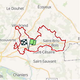
Tocht Mountainbike van 39 km beschikbaar op Nieuw-Aquitanië, Charente-Maritime, La Chapelle-des-Pots. Deze tocht wordt voorgesteld door tracegps.

Beschrijving

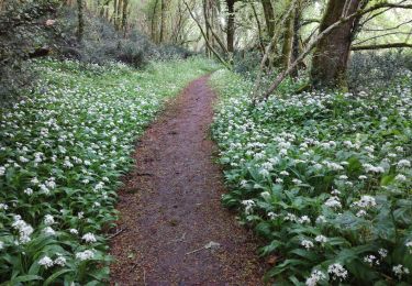
Ce circuit est celui d'une randonnée VTT de 40km organisée le 21 mars 2010. Au coeur du Pays de la Saintonge Romane, ce circuit nous fait profiter du charme des forêts, des ruisseaux et des fontaines parsemées le long du parcours. Le chemin peut facilement être abrégé. Il est plutôt roulant malgré quelques passages techniques éparses.

Hoogteprofiel

Foto's

Plaatsbepaling

Land:
France
Regio :
Nieuw-Aquitanië
Departement/Provincie :
Charente-Maritime
Gemeente :
La Chapelle-des-Pots
Locatie:
Unknown
Vertrek:(Dec)
Vertrek:(UTM)
691310 ; 5070051 (30T) N.

Wandeltochten in de omgeving

Tocht Paard La Chapelle-des-Pots - Circuit des potiers - La Chapelle des Pots - Photo
Paard
tracegps

Paard

Gemakkelijk
(1)
La Chapelle-des-Pots, Nieuw-Aquitanië, Charente-Maritime, France
7,2 km | 8,5 km-effort
1h 19min
Ja
Tocht Stappen La Chapelle-des-Pots - la Chapelle des Pots ( D ROUSSET) - Photo
Stappen
Claudinette17

Stappen

Medium
(1)
La Chapelle-des-Pots, Nieuw-Aquitanië, Charente-Maritime, France
7,8 km | 8,8 km-effort
2h 40min
Ja
Tocht Stappen Chaniers - port huble - Photo
Stappen
ninie51

Stappen

Medium
Chaniers, Nieuw-Aquitanië, Charente-Maritime, France
5,6 km | 6,5 km-effort
1h 39min
Ja
Tocht Stappen La Chapelle-des-Pots - La Chapelle des Pots - Asphodèles - Photo
Stappen
Claudinette17

Stappen

Gemakkelijk
(1)
La Chapelle-des-Pots, Nieuw-Aquitanië, Charente-Maritime, France
7,4 km | 8,7 km-effort
2h 5min
Ja
Tocht Mountainbike Le Douhet - Circuit des Arches de Fontcouverte - Photo
Mountainbike
tracegps

Mountainbike

Moeilijk
Le Douhet, Nieuw-Aquitanië, Charente-Maritime, France
16,5 km | 19,8 km-effort
1h 15min
Ja
Tocht Mountainbike La Chapelle-des-Pots - Circuit des potiers - La Chapelle des Pots - Photo
Mountainbike
tracegps

Mountainbike

Gemakkelijk
La Chapelle-des-Pots, Nieuw-Aquitanië, Charente-Maritime, France
7,2 km | 8,5 km-effort
34min
Ja
Tocht Stappen La Chapelle-des-Pots - Circuit des potiers - La Chapelle des Pots - Photo
Stappen
tracegps

Stappen

Medium
La Chapelle-des-Pots, Nieuw-Aquitanië, Charente-Maritime, France
7,2 km | 8,5 km-effort
2h 0min
Ja
Tocht Stappen Saint-Césaire - La Vallée du Coran - St Bris des Bois - Photo
Stappen
tracegps

Stappen

Medium
Saint-Césaire, Nieuw-Aquitanië, Charente-Maritime, France
7,4 km | 8,9 km-effort
2h 0min
Ja
Tocht Stappen Vénérand - venerand - Photo
Stappen
jpland17800

Stappen

Zeer moeilijk
Vénérand, Nieuw-Aquitanië, Charente-Maritime, France
24 km | 28 km-effort
6h 21min
Neen


Sluiten
Mijn abonnementen